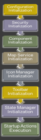
Framework Initialization
Caliburn Micro
See Main Article
Caliburn MicroThe framework makes extensive use of MVVM patterns (
Model View ViewModel). To facilitate the use of MVVM, the framework uses an open source framework
Caliburn Micro. There are three main parts of the caliburn framework that are used: MVVM support, Coroutines, and Conductors.
- MVVM Support - Caliburn Micro allows the developer to use convention based binding between views and viewModels.
- Coroutines - Coroutines allow the aggregation of async processes into a synchrounous workflow.
- Conductor - Simplifies the development of Ui's with a workflow component.
Existing Coroutines
See Main Article
Existing CoroutinesThe GIS Framework includes coroutines that have already implement IResult to allow faster development.
Layout Rendering
See Main Article
Layout RenderingComponents that have a visual presentation also have a number of options on how to display the view. There are two main options: showing xaml user controls, or UI generation based on view models. Showing xaml user controls is more appropriate for advanced UI's, whereas the auto-generated is more useful for simple data input UI's or for developers with less Silverlight skill. All of the views are displayed inside of a floatable window.
Map Interaction
See Main Article
Map InteractionComponents have a number of options for interacting with the map. The GIS framework has built in functionality for zooming and panning the map though the MapHandler. Geometry can be selected by the user by using the GeometrySelectionService. Finally components can draw graphics on the map through the GraphicsManager.
Querying
See Main Article
Querying A MapServiceThe QueryManager class provides an API for issuing queries against the data sources registered for a virtual application. Data sources must implement the FDOT.GIS.Client.Domain.IQueryableDataSource interface which provides the ability to Query, Identify or Find data features.
Displaying Results
See Main Article
Displaying ResultsThe framework has a standard way of displaying results in the application. This is accomplished through the ResultsDisplayManager. By using the ResultsDisplayManager to display results, you get built in sorting, filtering, grouping and the use of the data exporters and the data visualizers in the framework.
Advanced GIS Functionality
See Main Article
Advanced GIS FunctionalityThe GIS Framework contains a number of GIS Functionalities that are already supplied. Some of this functionality involves the ability to perform Measurements, Unit Conversions, ConvexHulls, and Geometry Encoding.
See Also